
Sierra Helada. Rutas.
- 5 mar 2020
- 7 min de lectura
Y en ésta parte del post, os hablaremos de las mejores rutas y puntos de interés que podréis encontrar en éste Parque Nacional de Sierra Helada.

Puesto que la superficie de Sierra Helada es compartida tanto por Benidorm como de su vecina L'Albir, nos encontraremos con tres rutas principales:
La Punta del Cavall. Ruta en la costa de Benidorm.
El Faro del Albir. Ruta en la costa del Albir.
Sierra Helada. Une ambas localidades, por lo tanto es la más larga y completa.
La Punta del Cavall
La primera de ellas, podríamos considerarla la más fácil, con una duración aproximada de 2 horas, y un recorrido de 5 km. ida y vuelta. Y nos llevará al 'Mirador de Serra Gelada', o también llamada 'Punta del Cavall'.

Empezaremos la marcha en Benidorm, desde la zona de Levante. Avenida Madrid, subimos y bordeamos la costa, y nos encontraremos con la 'Cala Almadraba' (playa nudista) a nuestra derecha. Más adelante llegaremos al comienzo de la ruta propiamente dicha, hallaremos un cartel indicativo y unas cadenas bloqueando el paso a vehículos. Una vez en éste punto tenéis la posibilidad de visitar la 'Cala del Tío Ximo', una pequeña pero preciosa playa, y que no es tan conocida ni concurrida como las principales, por lo cual podéis bañaros sin problema alguno.
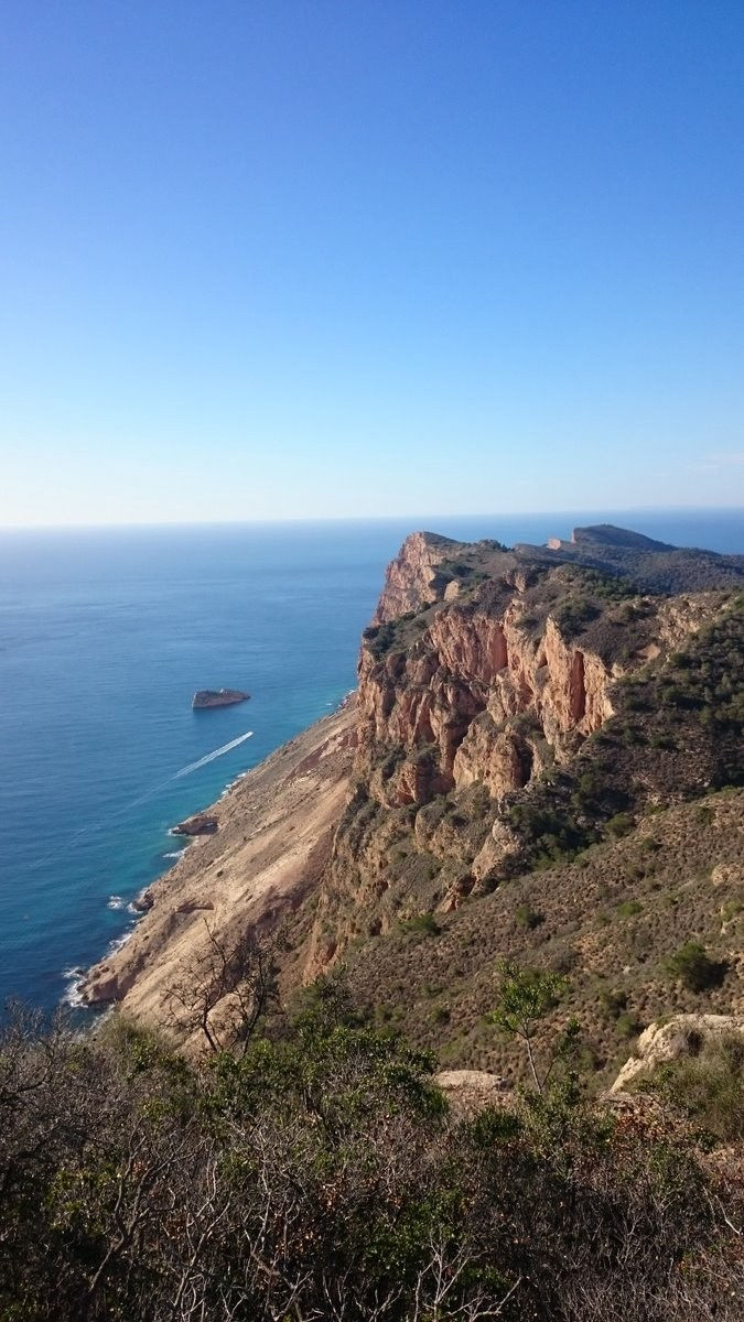
Éste sendero nos guiará hasta el Mirador de Serra Gelada, donde se encuentra una Torre vigía del siglo XVII. Aquí tendréis un punto prefecto para contemplar unas vistas impresionantes de los acantilados del Parque.

El Faro del Albir
También podemos considerarla una ruta para toda la familia, unos 5 km de longitud entre ida y vuelta. Podréis hacerla paseando, practicando running o en bicicleta. La ruta comienza desde el Punto de Información del Albir, siguiendo la senda que empieza desde el merendero. Todas las rutas estas señalizadas con color amarillo, así que seguimos la vía principal hasta encontrarnos con varios miradores en los que podemos disfrutar de unas maravillosas vistas de Altea y de la Bahía del Albir.
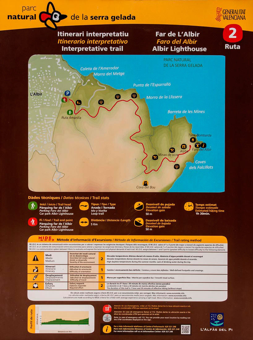
En éste camino tendréis la oportunidad de apreciar los acantilados y las olas fosilizadas famosas en ésta Sierra. Y tomar varios desvíos para apreciar la playa de 'La Cala La Mina', la impresionante cueva (sin camino para llegar)la 'Boca de la Balena' o las antiguas Minas de Ocre, a través del 'Camí de la Cantera'.
Al final del recorrido nos encontraremos con el Faro que da nombre a la ruta, con un Centro de Interpretación donde encontrarás la historia e información sobre estos lugares.

La Ruta de Sierra Helada
La más larga y dura de todas si vas a pie, pero podéis realizarla tanto andando, como en vehículo o bicicleta. Recorre el Parque Natural de un extremo a otro; sólo el camino de ida son 8,4 km. Y la podéis comenzar tanto desde El Albir como desde Benidorm, puesto que éste recorrido une ambas localidades.
Si salís desde Benidorm, podréis comenzarla como la primera ruta, desde la zona de Levante. Viene marcada con indicativos blancos y amarillos desde el punto de Información Turística del Rincón de Loix, situado en el cruce de la calle Gerona con Avenida Derramador. Desde este punto nos dirigiremos hacia la Sierra por la calle Gerona, para luego girar hacia la playa por la Avenida de L'Ametlla de Mar.
Una vez en ruta, en la subida podremos dirigirnos hacia la derecha hasta un mirador, desde donde tendremos una excelente panorámica de los acantilados o seguir subiendo hacia la izquierda, donde el final de la carretera nos conducirá a una pequeña senda que nos llevará hasta la famosa Cruz, punto icónico en Benidorm, cuya historia te contamos en éste otro post, y en dónde merece la pena hacer una parada en el camino para contemplar el precioso skyline benidormense. (el camino hasta la Cruz de Benidorm se puede considerar ya como una ruta propiamente dicha, pero la hemos englobado como parte de la ruta completa al igual que El Faro del Albir).

Después de esto podemos continuar hacia el 'sendero de las antenas' (llamado así por las antenas allí instaladas), siempre señalizado, guiándonos por el borde la Sierra hasta llegar al punto más alto del Parque, el 'Alt del Governador' o 'Alto del Gobernador', con 440 metros de altura y dónde están instaladas varias antenas de telecomunicaciones de. Desde aquí podréis apreciar casi todo, incluídas la 'Illa Mitjana' y el 'Puig Campana'.
La bajada es un camino en forma "serpenteante" hasta llegar a la Ruta del Faro del Albir, que una vez completad podríamos decir que hemos completado el recorrido.
Podréis encontrar éstas rutas y otras muchas en 'Google Maps' o en 'Wikiloc', portal en el que podréis buscar rutas al aire libre por todo el mundo. Os dejamos el enlace de ésta última Ruta de Sierra Helada:
Ya sea en vacaciones o no, si queréis pasar un día perfecto con la naturaleza y el mar como escenario, disfrutar de unas vistas únicas, tomar el sol o simplemente despejar la mente, éste es un plan que te aconsejamos muy seriamente :)
SERRA GELADA NATURAL PARK. ROUTES. (English translation)
And in this part of the post, we will talk about the best routes and points of interest that you can find in Sierra Helada National Park.

Since the area of Sierra Helada is shared by both Benidorm and its neighboring L'Albir, we will find three main routes:
Punta del Cavall. Route on the coast of Benidorm.
Albir Lighthouse. Route on the Albir coast.
Sierra Helada. It unites both locations, therefore it is the longest and most complete.
Punta del Cavall The first one, we could consider it the easiest, with an approximate duration of 2 hours, and a 5 km route. round trip. And it will take us to the 'Mirador de Serra Gelada', or also called 'Punta del Cavall'.
We will start the march in Benidorm, from the Levante area. In Madrid Avenue, we climb and border the coast, and we will find the 'Cala Almadraba' (nudist beach) on our right. Later we will arrive at the beginning of the route itself, we will find an indicative sign and chains blocking the passage to vehicles. Once at this point you have the possibility to visit the 'Cala del Tío Ximo', a small but beautiful beach, and that is not as well known or crowded as the main ones, so you can bathe without any problem. This path will lead us to the Mirador de Serra Gelada, where there is a 17th century watchtower. Here you will have a prefect point to contemplate stunning views of the cliffs of the Park.
Albir Lighthouse
We can also consider it a route for all publics, about 5 km in length between roundtrips. You can do it walking, running or cycling. The route starts from the Albir Information Point, following the path that starts from the picnic area. All routes are marked with yellow, so we follow the main road until we find several viewpoints where we can enjoy wonderful views of Altea and the Bay of Albir.
On this road you will have the opportunity to appreciate the famous fossilized cliffs and waves in this Sierra. And take several detours to appreciate the beach of 'La Cala La Mina', the impressive cave (with no way to get there) the 'Boca de la Balena' or the old Minas de Ocre, through the 'Camí de la Cantera'.
At the end of the tour we will find the Lighthouse that gives its name to the route, with an Interpretation Center where you will find the history and information about these places.
The Sierra Helada Route The longest and hardest of all if you do it walking, but you can do it both on foot, as in a vehicle or bicycle. Walk the Natural Park from one extreme to another; Only the way there is 8.4 km. And you can start both from El Albir and from Benidorm, since this route joins both locations. If you leave from Benidorm, you can start it as the first route, from the Levante area. It is marked with white and yellow signs from the Tourist Information point of 'Rincon de Loix', located at the intersection of Gerona Street and Derramador Avenue. From this point we will head towards the Sierra Helada on Gerona street, then turn towards the beach on Avenida de L'Ametlla de Mar. On route, on the way up we can go to the right to a viewpoint, from where we will have an excellent view of the cliffs or continue up to the left, where the end of the road will lead us to a small path that will take us to the Famous 'Benidorm Cross', an iconic spot in Benidorm, whose story we tell you in this other post, and where it is worth making a stop along the way to contemplate the beautiful Benidorm skyline. (The road to the Cross of Benidorm can already be considered as a route itself, but we have included it as part of the complete route as well as El Faro del Albir).
After this we can continue to the 'path of the antennas' (named for the antennas installed there), always signposted, guiding us along the edge of the Sierra until we reach the highest point of the Park, the 'Alt del Governador' or 'Alto of the Governor', with 440 meters high and where several telecommunications antennas are installed. From here you can appreciate almost everything, including the 'Illa Mitjana' and the 'Puig Campana'.
The descent is a "winding" way to reach the Route of the Albir Lighthouse, which once completed we could say that we have completed the tour.
You can find these routes and many others on 'Google Maps' or on 'Wikiloc', a portal where you can search for outdoor routes all over the world. We leave you the link of this last Route of Sierra Helada: https://es.wikiloc.com/rutas-sen Hiking/serra-gelada-sierra-helada-26112015-11504888
Whether on vacation or not, if you want to spend a perfect day with nature and the sea as a stage, enjoy unique views, sunbathe or just clear your mind, this is a plan that we advise you very seriously :)


Comentarios